The Sections (Northern Coast)
The Edge of Wales Walk is divided up into 9 distinct sections, taking you from the ancient church of St Beuno at Clynnog Fawr, all the way along the northern coastal path of the Llŷn Peninsula to Aberdaron and Bardsey Island. Each one has something unique to offer the walker, with historic churches, ancient archaeological sites, spectacular views and stunning scenery. The sections also offer different challenges, with a variety of walking experiences, from mountain paths, to sheep-tracks and sandy beaches, with more or less challenging alternatives to suit your ability.
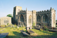
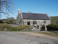
The huge church of St. Beuno, its separate Chapel, the Holy Well and the Cromlech burial chamber dating from the New Stone Age and altered in the Bronze Age together with the many legends in folklore testify to Clynnog Fawr as a site of continuous religious importance since the time of the First Farmers. The walk winds up the lanes from the fertile valley to the upland pastures and on to the mountain moor before descending to the village of Llanaelhaearn whose ancient church contains a number of Latin inscribed stones believed to date from the 6th Century AD.
Distance: 8 miles / 12.8 km
Terrain: Steady uphill walking, then gentle downhill slope across an exceptional grassland moor. On a fine day you can see four countries - Ireland, Man, England and Wales.
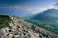
Tre’r Ceiri - "Town of the Giants" is the largest and best preserved Iron Age Hillfort in Wales. It contains the well preserved remains of 150 huts and must, in its heyday during the Roman occupation, have had a large population. The outer wall is intact and encloses also a huge Bronze Age burial cairn.
Distance: 6 miles / 9.6 km
Terrain: Steady uphill walking on road and then a steep walk on a prepared path with some loose stones up to the Fort, and then a long descent to the villages of Llithfaen and Nant. Fabulous views of Snowdonia to the East and along the Llŷn to the West.
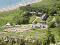
Nant Gwytheyrn translates as the valley of Vortigern, one of the last Kings of the Celtic Britons who fled here from the Saxon invasions in the 6th Century. It was subsequently an isolated farming community, home of one of the largest granite quarrying complexes in Britain and now host to the Welsh Language and Heritage Centre. Pistyll has a classic single naved 12th Century Pilgrim Church which incorporates a leper window. Ancient medieval herbs used to cure the many sick Pilgrims can be seen growing in the churchyard.
Distance: 5 miles / 8 km
Terrain: A winding track down to the beach leads on through sessile oak woods up the cliffs to the old quarry and then through some flat stone walled meadows above the sea coast leading to Pistyll. Undulating tracks through fields and forest show us views towards Porth Dinllaen and take us into Nefyn.
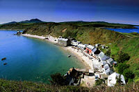
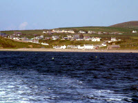
Nefyn was once the principal town of Llŷn. Edward 1st celebrated his victorious campaigns here, Owain Glyndwr burnt the town but it later grew prosperous from herring fishing, boat building, and sea-faring, which you can find out about in the recently reopened Llyn Maritime Museum. The village on the sand at Dinllaen, with its little harbour and remains of a promontory fort, is now owned by the National Trust. You can stop for a drink at the charming Ty Coch Inn.
Distance: 8 miles / 13 km
Terrain: Very easy walking on the paths of Nefyn along the beach to Porth Dinllaen, and at the edge of the golf course. This leads on to undulating cliff walking where the odd scramble up grassy slopes is necessary. This is coast walking all the way with interesting grasses, wild flowers and also plentiful seals near the lifeboat station.
The church of St Gwynhoedl is one of the architectural gems of Llŷn. Its three naves are testament to the prosperity bought by thousands of Pilgrims. This coast was a notorious haunt of smugglers in the 17th and 18th centuries and is also a famous shipwreck coast. The remains of a vessel smashed on the rocks can still be seen at low tide at Porth Mawr.
Distance: 7 miles / 11.3 km
Terrain: This is steady walking on soft grassy cliffs and long sandy beaches until the path takes us inland along lanes to the Church at Llangwnnadl.
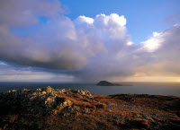
The path takes us past the old jasper mines of Carreg and through a landscape where the fields grow increasingly small and wildlife abounds. This is chough country and refuge to migrating sea birds. Mynydd Mawr is the Lands End of Wales with a coastguard lookout and the remains of wartime gun emplacements. The remains of St Mary’s Church can still be seen on the headland and St Mary’s Holy Well right at the sea edge marks the very last Holy Well from which Pilgrims would drink before their little boats braved the treacherous waters of the Bardsey Sound.
Distance: 7 miles / 11.3 km
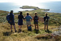
Terrain: After further cliff walking the path is forced inland along lanes before descending to the famous sandy beach of Whistling Sands. It then begins a steady climb on cliffs and moor through gorse and heather up to Mynydd Anelog and later Mynydd Mawr from where superb views can be gained of the whole of Llŷn stretching back to the hills where the walk began. As soon as the summit of Anelog is gained the Holy Isle of Bardsey in its entirety is sighted for the first time in our journey.
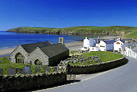
Aberdaron is the most westerly village in Llŷn. An old fishing and shipping settlement, its church was founded in the 6th Century by St Hywyn, a follower of St Cadfan. This magnificent 12th Century double naved church was known as the "cathedral of Llŷn" and enjoys a spectacular setting overlooking the beach. Also in the village is the "Gegin Fawr", the "Big Kitchen", where Pilgrims since the 13th Century have been able to take their last meal before crossing to Bardsey Island.
Distance: 4 miles / 6.4 km
Terrain: This is all gentle but spectacular cliff walking through National Trust property overlooking Bardsey Island, on to the wild headland of Pen y Cil and then to Aberdaron Bay. There is plenty of coastal heath-land rich in bird life and wild flowers in which to wander undisturbed.
Bardsey is known in Welsh as Ynys Enlli, the Isle in the currents. Situated at the meeting point of the Cardigan Bay and the Irish Sea tidal systems, this is one of the most treacherous stretches of water in the British Isles. But safety is paramount and the Bardsey boat will only sail if conditions are right. Look out for puffins, oyster catchers, seals and dolphins.
Distance: 4 miles / 6.4 km
Terrain: This is a four mile trip by boat leaving from Porth Meudwy (hermit’s cove), a little fisherman’s cove near Aberdaron. You will enjoy views right up the coast towards Porth Meirion, and see the glory of Pen Llŷn from the sea.
To the medieval mind the completion of such a pilgrimage gained actual atonement for sins committed and lessened the time the Pilgrim would spend in Purgatory before gaining entrance to Heaven. Three Pilgrimages to Bardsey were said to equal one to Rome itself. The voyage across the treacherous Sound represented a voyage, if not to Heaven itself but part way to the "other side, the very porch of Heaven" There is now a bird observatory and a lighthouse here, but the Island itself is administered by a Trust and, with close supervision by the Countryside Council for Wales, preserves the Island as a superb nature reserve. Over 150 Seals live off the rocks of the Island.
Distance: 2 miles / 3.2 km
Terrain: The final journey across the Island of Bardsey takes us up to the mountain from where we can look back to the land from which we have come, and then takes us down a mountain path to the ruins of St Mary’s Abbey itself and the High Cross which marks the end of the Pilgrimage.